UK's Best Long-Distance Walks 2023 | Top 7 Backpacking Trails
Make this a year of adventure and embark on a big walk. Here are 7 backpacking trips to sate your wanderlust and soak up some of Britain's most spectacular landscapes.
25th August 2023 | Words by Matt Jones @ WildBounds HQ
“If everyone in the world took care of each other the way folks do out on the trail, and if everyone approached each day with as much hope and optimism as hikers do, the world would be a better place.” – Jon Tullis
As far as we're concerned, backpacking a long-distance trail is one of the most fundamental, life-affirming outdoor activities you can do. There’s the promise of adventure, the chance to soak up stunning landscapes, meet fellow hikers along the way and take a journey into the unknown. There's also the sense of challenge and the accompanying feeling of accomplishment, the satisfaction that comes with knowing you are carrying all you need on your back, and later, the triumph you'll feel when reaching a long-held goal, crossing that finish line with hard-won miles under your belt. Tempted? Here are our top long-distance trails in the UK.
How many long-distance walks are there in the UK?
According to the database of the Long Distance Walkers Association (LDWA), there are currently 818 long-distance paths in the UK (defined as a route of more than 30 miles in length). This figure includes the 16 national trails of England and Wales and many hundreds of other named long-distance routes in the UK, including 29 Great Trails in Scotland. In total, England and Wales have around 2,500 miles (4,000 km) of national trail. So, there ought to be no shortage of routes to walk. But how do you pick one?
What is the longest walk in the UK?
If it's a challenge you're after, then this is the first question you might ask. At present, the longest continuous footpath in the UK is the 630-mile South West Coast Path, an epic coastal route. However, this will soon be surpassed by the forthcoming England Coast Path, which is currently being opened in stages and when complete will run to some 2,795 miles (4,500 kilometres) in total.
What is the shortest national trail?
On the other hand, if you're pushed for time, you might want to try something more manageable. The Yorkshire Wolds Way is actually the shortest of the National Trails, at 79 miles long, closely followed by the Hadrian's Wall Path, at 84 miles. Either of these routes can be walked in 5 or 6 days.
And while Scotland boasts some epic Great Trails, the longest being the 214-mile Southern Upland Way, it actually also has no less than 15 trails that are all under 60 miles in length. These range from the wee Dava Way (24 miles, walkable in one long day) to the Great Glen Canoe Trail, which just sneaks in at 59.7 miles and can be completed by boot, bike or boat.
Can you walk across the UK?
This is another popular question. Since Britain is an island nation, it's tempting to want to traverse it from one side to the other. It is of course possible, and the most popular way to do it is to follow Wainwright's Coast-to-Coast, a 182-mile route than runs from west Cumbria to the North Yorkshire coast.
These are all grand adventures, and ones that are far easier to work around day-to-day life than other famous 'thru-hikes' like the Pacific Crest Trail, the Appalachian Trail or the Continental Divide. Let's face it, we're not all Cheryl Strayed or Bill Bryson, nor committed backpackers who can afford to drop everything for months at a time. Many of the most spectacular long-distance hiking trails to be found right here in the UK can be completed in a matter of days or a couple of weeks: the perfect way to do something different and memorable with your annual leave. So, what are you waiting for? After all, every journey begins with a single step.
Click to view map
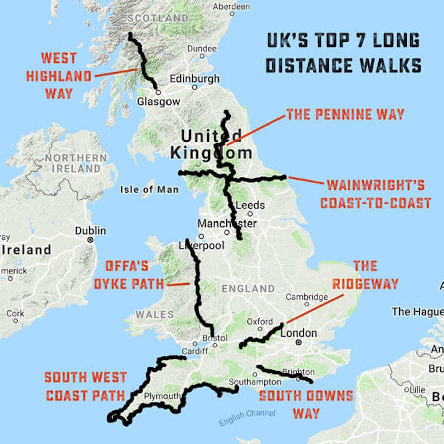
UK's Top 7 Long Distance Walks
From the majestic Scottish Highlands to the windswept coastal cliffs of Devon and Cornwall, we’ve scoured a map of the UK to come up with our top seven extraordinary hiking trails, ranging from 87 miles in length to an incredible 630. Each of them offers the chance to experience a grand journey: hiking along clifftops, over hills and through forests, stopping each night to pitch a tent or enjoy the comforts of a walkers' inn, far from the stresses of everyday life. For each, we’ve outlined the key details you need to start planning your trip, including our favourite places to stay, cafes and tour providers along the way. To experience an adventure and start living a life with fewer bounds, going for a very long walk is a terrific start.
Stormy skies over the dramatic landscape of the West Highland Way | Credit: Sigge Bjerkhof
#1 West Highland Way
Click to view map
Length 95.7 miles (154 km) Average time taken to complete 8 days Start/finish Milngavie to Fort William
One of the UK’s most famous long-distance trails, the West Highland Way encompasses some truly phenomenal terrain along Scotland’s west coast. From Milngavie (pronounced 'Mul-guy'), north of Glasgow, to Fort William by the north shore of Loch Linnhe, the 96-mile path carves through mountain passes, skirts along loch edges and strides out over windswept moorland. Thanks to that often-daunting terrain, the Way can take hikers over a week, though many complete the whole trail in five days. Most hikers plan to traverse the Way from south to north, since the third quarter is regarded as the most challenging: from Tyndrum to Kinlochleven, the ascent regularly climbs to above 500m.
Traversing the entire route under your own steam is a challenge that many hikers take on, carrying their own provisions and camping along the way. Although a worthy pursuit, anyone who has spent much time in Scotland’s Western Highlands knows that sleeping under canvas can be risky at best, due to the changeable conditions and the fearsome and notorious Scottish Midge. That swift one-two of unpredictable weather and wee beasties helps to explain the popularity of hiker-friendly inns and B&Bs at regular intervals along the route, though we reckon the promise of a shower and hot meal after several days of trekking will help, too.
AccommodationThe Kingshouse Hotel in Kinlochleven is a popular final stop for travellers taking the classic northerly route up the West Highland Way, partly explained by its proximity to the trail and partly by the “Way Inn”, a bar designated for outdoor hikers since the 1750s.
Food & Drink A homely cafe located in Loch Lomond and the Trossachs National Park, Artisan Cafe & Deli Tyndrum serves delicious coffee, sandwiches and cake –essentially, everything a hungry hiker needs.
Extras Hiking alone in any terrain can be a challenge –hiking the West Highland Way solo is an even more daunting feat. With Thistle Trekking, you not only are guided by an experienced mountain leader, you’ll hike with a group and have all your accommodation provided along the route.
The Pennine Way | Credit: Annie Spratt via Unsplash
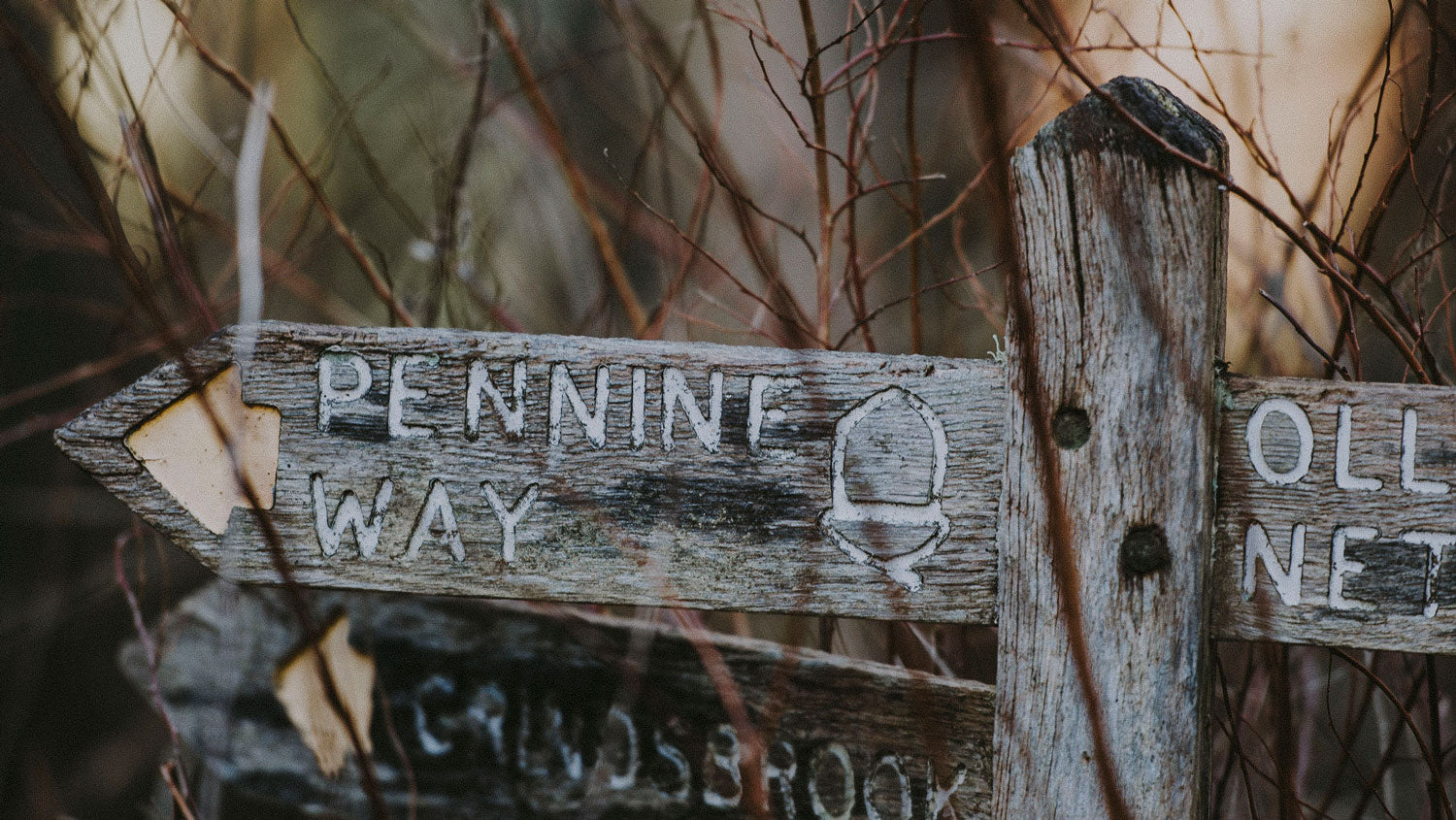
#2 Pennine Way
Click to view map
Length 268 miles (429 km) Average time taken to complete 16-19 days Start/finish Edale, Derbyshire to Kirk Yetholm, Scottish Borders
Meandering along the spine of northern England to its border with Scotland, the Pennine Way is the veritable grandaddy of the UK’s National Trails. From the picturesque village of Edale, nestled in the Peak District, the path snakes across moorland, through valleys and over misty fells to its end at Kirk Yetholm, on the far side of the Cheviots. The Pennine Way was the UK’s first official National Trail and is by far one of its most popular. Its southern section through the Peak District is particularly well-walked throughout the summer months. It also hosts the gruelling Spine Race, a challenging trail run over the entire 256-mile route, though not all attempts have to be that intense.
Hiking the entire trail will take the best part of three weeks and the recognised direction is to travel north, starting in Edale and finishing in Kirk Yetholm. Simon Armitage, the poet whose account of walking the entire Pennine Way as a modern troubadour, Walking Home, has inspired many hikers, travelled south from the Scottish border and gives a detailed account of the terrain along the way. Camping is an option but the weather can be fierce, particularly across open moorland where fog increases the danger of losing your way. B&Bs cater to hikers along the entire route and the National Trails website gives a detailed itinerary for those aspiring to walk all the way.
Accommodation Roughly a third of the way along the Pennine Way, travelling north, Malham is a key stop for thru-hikers, marking the transition from the South Pennines to the Yorkshire Dales. While there, be sure to stop at The Lister Arms, a homely inn with comfortable rooms, hearty food and a log fire to relax in front of.
Food & DrinkThe Old Nag’s Head in Edale, right at the start of the Pennine Way, might seem an odd suggestion for a place to eat along the trail, but it’s earned it. The night before you set off, grab a portion or two of beer-battered chips and a pint to match, amidst the exposed beams and low ceilings of this fantastic pub dating back to 1577.
Extras Organising your own accommodation can be a faff –if you’re planning to thru-hike the Pennine Way, you don’t need any complications. Macs Adventure will arrange all your accommodation with breakfast included every day and luggage transfers, so you can concentrate on bagging the miles.
Hiking in the South East yields some spectacular views | Credit: @maxey_images
#3 South Downs Way
Click to view map
Length 100 miles (160 km) Average number of days to complete 8-9 days walking, 2-3 days cycling Start/finish Winchester, Hampshire to Eastbourne, East Sussex
Although not an easy walk by any means – it still covers 100 miles across undulating terrain – the South Downs Way was designated as the UK’s first National Bridleway, which means its path is wider and steadier than those through the mountains. Running from Winchester to Eastbourne, the Way is a quintessentially English path, journeying across green fields and through sleepy stone villages. If you tackle the South Downs in summer, as most hikers and mountain bikers do, you’ll be treated to some beautiful views, particularly as you approach the white cliffs at the paths’ end.
The South Downs Way is a popular thru-hike – i.e. traversing the entire distance in one trip rather than walking it section by section with breaks between – thanks to the forgiving terrain, accessible location and availability of B&Bs and inns along its path. Although the route skirts past major cities such as Southampton and Brighton, for the majority of its course the path marches through exquisite countryside, giving hikers a true sense of escaping urban life and connecting with the natural world. It passes by five National Nature Reserves, so the chance of spotting wildlife is particularly high. Amidst the hustle and bustle of the South East, the South Downs Way is a true gem.
Accommodation Once the home of Royal Navy trainees, Weatherdown Lodge has been refurbished to provide weary hikers with a comfy bed for the night. It’s located in the Sustainability Centre, an independent learning and study centre that has been awarded for its efforts to educate people on sustainability and environmentalism.
Food & Drink A small establishment by the side of the South Downs Way, just north of Brighton, Wildflour Cafe is a hidden gem in the South East. Serving wholesome food, including delicious cakes, it’s a brilliant opportunity to kick off your hiking boots and refuel before getting some more miles under your feet.
ExtrasHF Holidays offer a 10-day guided tour of the South Downs Way, beginning in Winchester and walking across the countryside to Eastbourne. An experienced guide will lead the way and impart local knowledge along the route, including the ancient history of the path itself.
Wales' phenomenal landscape is laid out before you on Offa's Dyke | Credit: Neil Thomas via Unsplash
#4 Offa's Dyke Path
Click to view map
Length 177 miles (285 km) Average number of days to complete 14 days Start/finish Chepstow, Monmouthshire to Prestatyn, Denbighshire
In the 8th century, King Offa of Mercia built an 8m rampart from Prestatyn to Chepstow as a defensive barrier against the marauding Celts, who crossed the border from wild Wales. More than 1,200 years later, that fortification is a National Trail that carves through unbelievable scenery across the length of Wales, one that spans 177 miles and takes roughly two weeks to traverse.
From Prestatyn, on the shores of the Irish Sea, Offa’s Dyke travels south through the Clwydian Range and the Marches, crossing between England and Wales more than 20 times on its path to Chepstow on the Severn estuary. Along its way, the Dyke passes through the Wye Valley –an Area of Outstanding Natural Beauty –and skirts along the edge of the Brecon Beacons. The terrain can be tough-going in places, particularly through the Clwydian Range and along the Brecons, but also features more gentle segments in valleys and along the Montgomeryshire Canal. The National Trails website states that the total ascent travelling south to north is 28,000ft, which is the same height as Mount Everest.
Accommodation Built as a Coaching Inn in 1630, the Dragon Hotel is a historic, independent establishment in the picturesque town of Montgomery, roughly halfway along Offa’s Dyke. With comfortable, luxurious rooms, it’s the perfect place to take a rest day on your journey along this historic path.
Food & Drink A country pub near Abergavenny, on the edges of the Brecon Beacons, the Hunters Moon Inn serves home-cooked food using locally sourced ingredients, including meat from farms nearby, but its ale is what draws most travellers. A member of CAMRA and in the Good Beer Guide, the Inn offers a wide variety of beers, all poured to perfection.
Extras A self-guided expedition from Chepstow to Knighton provided by Sherpa Expeditions, this route covers the southern half of Offa’s Dyke and includes nightly accommodation, breakfast each day and luggage transfers over a week of hiking.
Hiking through the Lake District at dawn | Credit: Wesley Henshaw via Unsplash
#5 Wainwright's Coast-to-Coast
Click to view map
Length 182 miles (293 km) Average number of days to complete 12-14 days Start/finish St Bees, Cumbria to Robin Hood's Bay, North Yorkshire
Coast-to-coast attempts arise along the entire length of the UK but the Wainwright route has amassed a popular following since Alfred Wainwright first described it in his 1973 guidebook. It’s perhaps because the 190-mile walk takes in some of the most spectacular scenery that northern England has to offer, from the Lake District to the Yorkshire Dales and North York Moors. From towering mountains to windswept moors, the Wainwright Coast-to-coast is a journey through the beautiful but imposing landscape of the North.
The path begins in St Bees, Cumbria and charges straight into its most testing terrain, the Lake District. There are a few variations for the route, particularly through the mountains, but all are listed in Alfred Wainwright’s guidebook and other editions that have since been published. From the Lakes, the path continues east-to-south-east, carving through the Yorkshire Dales and across the centre of the North York Moors until its completion at Robin Hood Bay, north of Scarborough. Thanks to the often difficult terrain, the Wainwright is not a trail for inexperienced hikers –if the weather turns, as it often can across these three National Parks, the going can become difficult quite quickly. On a fair weather day, however, this coast-to-coast trail promises some astounding views of Northern England.
Accommodation The Howgills are a range of fells midway between the Lake District and the Yorkshire Dales, and so also a perfect opportunity to rest up between two challenging National Parks. Bents Camping Barn is an old shepherd’s cottage from the 1600s with 14 beds available, from £11 per person.
Food & Drink A family-run bike shop, café and B&B in the heart of the Yorkshire Dales, Dales Bike Centre is a great option for refuelling along the Wainwright Coast-to-coast. Their food is sourced locally and every effort has been made to improve the sustainability of the whole centre, from the bike shop to the café.
Extras To help guide your way on the more challenging sections of the Wainwright, Footpath Holidays have broken the route down into three segments and offered a guided tour of each one, including daily transfers.
Avebury stone circle | Credit: Lucy De Los Santos via Instagram
#6 The Ridgeway
Click to view map
Length 87 miles (139 km) Average number of days to complete 6 days Start/finish Avebury, Wiltshire to Ashridge Estate, Buckinghamshire
Although the shortest trail on this rundown of long-distance hikes, the Ridgeway still weighs in at a lengthy 87 miles, easily taking your effort into several days of walking. From Avebury, a world-famous UNESCO World Heritage Site, the path meanders through rolling hills and forests, across the North Wessex Downs and the Chilterns, until its culmination at Ivinghoe Beacon. Marching almost entirely through Areas of Outstanding Natural Beauty, the Ridgeway is one of the most scenic and pleasant long-distance paths in the UK, perfect for hiking throughout the year.
What makes the Ridgeway truly unique, though, is its heritage. Often referred to ‘Britain’s oldest road’, the path follows a route used since prehistoric times by travellers, traders and soldiers, meaning that every step you take will be following in the footsteps of our ancient ancestors. Along the way, you’ll encounter ruins of old forts, Stone Age and Bronze Age barrows, white horses carved in the chalk hills, and other cultural treasures. To hike the Ridgeway is to take a step back in time, despite the multitude of modern pubs and inns waiting at the end of each day’s walk.
Accommodation Located roughly halfway along the Ridgeway, the Fat Fox Inn is a superb place to stay for weary travellers, offering comfortable rooms and good food at reasonable rates.
Food & Drink Nestled in the Chilterns, Aldbury is a picturesque town not far from the Ridgeway’s end (if you start in Avebury, as most do). The Trooper is a recently refurbished village pub, nestled at the bottom of the Ashridge estate, offering wonderful food, a vast wine selection, some great beers, ales and ciders in a lovely setting, both inside and out.
Extras Long-distance hiking is, in our opinion, best enjoyed with a comfortable bed and hot meal at the end of each day –and if your baggage is waiting for you at the inn, even better. Booking with Macs Adventure guarantees all of that and provides a detailed guidebook and map to help you along.
The South West Coast Path offers mesmerising views | Credit: @cakejaggaley
#7 South West Coast Path
Click to view map
Length 630 miles (1014 km) Average number of days to complete 30 days as a dedicated thru-hike, otherwise 7-8 weeks Start/finish Minehead, Somerset to Poole, Dorset
By far the longest route in this collection, the South West Coast Path encompasses the entire coastline of Devon and Cornwall, from Minehead in Somerset, round Land’s End in Cornwall and along to Poole Harbour in Dorset. That 630-mile distance crosses some of the most dramatic and iconic landscapes in the British Isles, from the Jurassic Coast to the tin mines of Cornwall, with waves driving in from the Atlantic Ocean throughout. The drama of the South West Coast Path is one of the reasons so many hikers travel across the UK to walk sections of it.
Crossing between four counties, the sights to be seen and experiences to be had along the Path’s route are too varied to be shortly summarised –that’s the beauty of it. From surfing coves in North Devon to bustling promenades in Cornwall, it offers a huge wealth of outdoor experiences along its way.
Accommodation Lizard village, often known as ‘The Lizard’, is the most southerly village on the British mainland, which makes the Top House Inn mainland Britain's southernmost inn. It's your best bet for a comfy bed and hot meal in this dramatic location.
Food & Drink A small cafe tucked away on the Roseland Peninsula, Cornwall, The Hidden Hut is truly a hidden gem on the South West Coast Path. By day, they serve delicious home-cooked food and drinks with views along the coast; by night, they host weekly ‘feast nights’ with themes such as Lobster & Chips and Sticky Ribs.
ExtrasThere are many companies that provide a complete walking holiday package along parts of the South West Coast Path, including guided and self guided walks as well as themed walks from food foraging to wildlife watching. The excellent South West Coast Path Association website gives details of the major tour operators.
For more great resources to help you get started walking in the UK, check out Northern Eye Books' award-winning range of guides, complete with easy-to-follow routes and enhanced OS mapping, covering National Parks and long-distance paths across England, Scotland and Wales.